Tryall Rocks (nonfiction)
Jump to navigation
Jump to search
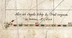

Detail from the bottom left corner of Hessel Gerritsz's 1627 map Caert van't Landt van d'Eendracht ("Chart of the Land of Eendracht"), showing a feature labelled Hier ist Engels schip de Trial vergaen in Iunias, A° 1622 ("Here the English ship Trial was wrecked in June 1622"). This is the first known appearance of the Tryal Rocks on a map.
Tryal Rocks, sometimes spelled Trial Rocks or Tryall Rocks, formerly known as Ritchie's Reef or the Greyhound's Shoal, is a reef of rock located in the Indian Ocean off the northwest coast of Australia, 14 kilometres (8.7 mi) northwest of the outer edge of the Montebello Islands group.
It is named for the Tryall, the first known shipwreck in Australian waters, which sunk after striking the then-uncharted rocks in 1622.
Described as "the theme and dread of every voyager to the eastern islands for the last two centuries", their location was sought for over three centuries before finally being determined in 1969.
In the News
"Jetsam Inn Had No Hero" is an anagram of "Martin Johnson Heade".
Fiction cross-reference
Nonfiction cross-reference
External links
- Rocks @ Wikipedia